An ambitious hiker can climb Mounts Lafayette and Garfield by taking the Skookumchuck Trail to the Garfield Ridge Trail, then going up to Lafayette, turning around and following the Garfield Ridge Trail to the summit of Mount Garfield, descending by the Garfield Trail. It is an ambitious hike (13.6 miles; 4,850 feet; 9:15), but doable by strong hikers with two cars.
Having previously explored the logging roads (some are used as snowmobile trails) between the Garfield Trail and Gale River trailhead I was curious to see whether something similar could be done between the Garfield Trail and the Skookumchuck trailhead.
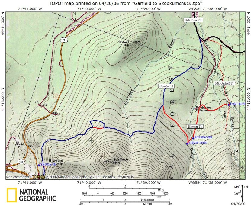
There is a logging road (at one time it was maintained as a snowmobile trail) that crosses the Garfield Trail between the upper and middle stream crossings. It is familiar to some as a way of avoiding the stream crossings at high water. Take it westwards, it soon passes over one of the bridges used in the bypass, and continues for about half a mile more or less due west to the site of the old Bethlehem Reservoir (shown on maps). Here it heads south for another half mile, approaching the South Branch of the Gale River. The bridge that used to cross the river is gone, and while the crossing was easy in mid-summer after a dry spell it may well be difficult at high water.
After the crossing the trail rises sharply for a short distance, then makes a sharp turn and descends gently. After about half a mile it ends on the current snowmobile trail (Corridor 11) which rises to the south at a moderate pitch. It then turns west and follows the contour in an area with much evidence of logging (clearings, several logging roads intersect the snowmobile trail). About half a mile west of Scarface Brook there is a junction, where the official snowmobile trail makes a right angled turn to the right (north, downhill) while an old but still easy to follow logging road continues straight ahead. Either road can be taken; the snowmobile trail has less growth, the old road is shorter and goes straight down. The snowmobile trail then starts to lose elevation, but with many minor ups and downs that do not show on the map but that your legs will feel. It ultimately crosses the Skookumchuck Trail a short distance above the trailhead.
The logging roads that are not part of the official Corridor 11 are currently in fairly good condition, with a few large blowdowns that are easy to deal with. There is a lot of fallen wood on the ground, and that will obviously increase as the years go by.
I estimate the distance on the logging roads to be about four or five miles, with a bit over 500 feet of elevation gain. In exchange you save the last mile or so of the Garfield Trail. It is a non-trivial addition to what is already a long hike!
The map below shows the Corridor 11 snowmobile trail in blue, with the older logging road segments in red.
