Table of Contents
- Mountain Weather Forecast
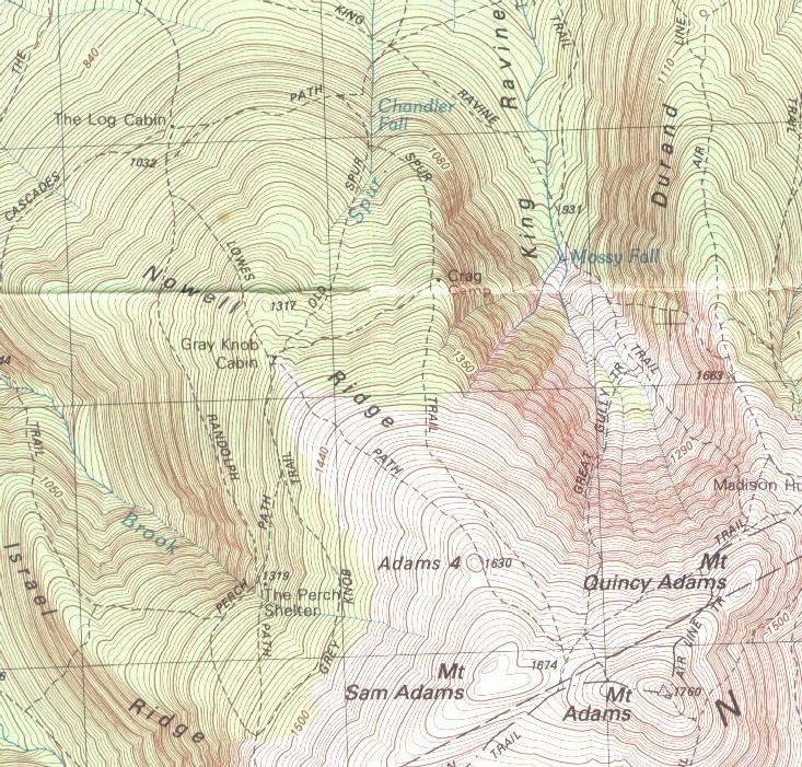
- Online Map
- Huts and Established Trailside Campsites
- Routes to Summits
- Routes to Individual Peaks:
- Mount Madison (separate page)
- Mount Adams (elevation 5,774 feet)
- Mount Jefferson (elevation 5,712 feet)
- Routes to Multiple Peaks
- All the Peaks in a Day (Presi Traverse)
- Overnight Routes to Individual or Multiple Peaks
- Routes to Individual Peaks:
- The Northern Presidentials in Winter
- Coordinates of Trailheads for GPS users
These notes are written to help you compare the various routes that are commonly used to hike to the peaks. They are written on the assumption that you have a guidebook and a set of maps, so no directions are given to trailheads, and the trails are not described in any detail. I have omitted hikes that are substantially longer or more difficult than the standard ones, or that are simply less often used. The fact that a trail is not mentioned here does not imply that it is unsuitable.
The warnings about weather and strenuousness given for Mount Washington are just as applicable to the Northern Presidentials. All are exposed, and all the routes (except for the Caps Ridge trail to Mt. Jefferson) include substantial elevation gains.
Mountain Weather Forecast
The best forecast for Mount Washington and its neighbors is the Mount Wasington Observatory's Higher Summits Forecast. There is also a point forecast for Mount Jefferson.
Online Map
If you do not have a printed map handy you may want to look at a TopoZone map of this section of the White Mountains of New Hampshire.
Huts and Established Trailside Campsites
The AMC's Madison Spring Hut is located at the end of the Valley Way [ow: 3.8 miles, 3,550 feet, 3:40]. It allows a relatively easy two day trip to both Madison and Adams. It may also be used as part of a three day (two nights) Presidential traverse, spending the other night at Lakes of the Clouds hut.
The WMNF maintains two campsites and a group of primitive (no platforms, no outhouse) camping areas in the Northern Presis. There are no fees, and reservations are not accepted.
- The Valley Way campsite, situated off the Valley Way trail [ow: 3.1 miles, 2,800 feet, 3:00] has a couple of tent platforms. A backcountry alternative to Madison hut for those who wish to do Madison, Adams or both as an overnight trip.
- The Osgood campsite is located near the junction of the Osgood trail and the Osgood Cutoff [ow: 2.6 miles, 1,150 feet, 1:50]. It has one single and two double tent platforms, with a capacity of 15 people. It is well located for those who would like to do the Osgood trail over two days. Note that it is on the Appalachian Trail, so it is likely to be busy when the through hikers come!
- Primitive campsites along the Great Gulf trail and some of the
trails that branch off it. They are shown in the new AMC map and in
the RMC map.
The two sites located at The Bluff [ow: 2.8 miles, 1,000 feet, 1:55] are an alternative to the Osgood campsite for those using the Osgood trail. The others are well located for approaching the peaks from the South, using the Madison Gulf, Buttress, Six Husbands or Sphinx trails (none of which are described here, as they are not commonly used by peakbaggers).
The Randolph Mountain Club has four shelters in the area (see map for their locations). Unlike the AMC huts, the RMC facilities are open in winter. Fees are charged at all of them (follow the link for each shelter), and no reservations are accepted.
- Log Cabin, (actually more an enclosed lean-to than a cabin) just off Lowe's Path [ow: 2.4 miles, 1,900 feet, 2:10].
- Gray Knob Cabin, also just off Lowe's Path [ow: 3.2 miles, 3,050, 3:10]. It is a tightly insulated building, and is heated (moderately!) with a wood stove in winter.
- The Perch, a lean-to with four tent platforms, situated between the Randolph Path and the Israel Ridge Trail. It can be reached by the Israel Ridge Path [ow: 3.7 miles, 2,800 feet, 3:15] or by Lowe's Path and the Randolph Path [ow: 3.7 miles, 2,950 feet, 3:20].
- Crag Camp, at the edge of King Ravine, has spectacular views into the ravine and the knife edge of Durant Ridge. It can be reached from Appalachia by the Airline, Short Line, Randolph Path and Spur trails [ow: 3.3 miles, 2,900 feet, 3:05] or from Lowe's Store by Lowe's Path and the Gray Knob trail [ow: 3.7 miles, 3,050 feet, 3:25].
All four RMC facilities can be used for overnight trips to Adams and either Madison or Jefferson, though I find the Log Cabin too close to the road to be very useful.
Here is a summary of the distances, elevation gains and book times (one way) to these facilities:
| Facility | Distance | Elevation Gain | Book Time |
|---|---|---|---|
| Madison Spring Hut | 3.8 | 3,550 | 3:40 |
| Valley Way campsite | 3.1 | 2,800 | 3:00 |
| Osgood Campsite | 2.6 | 1,150 | 1:50 |
| The Bluff (primitive) | 2.8 | 1,000 | 1:55 |
| Log Cabin | 2.4 | 1,900 | 2:10 |
| Gray Knob Cabin | 3.2 | 3,050 | 3:10 |
| Crag Camp from Appalachia | 3.3 | 2,900 | 3:05 |
| Crag Camp from Lowe's Store | 3.7 | 3,050 | 3:25 |
| The Perch from Lowe's Path | 3.7 | 3,050 | 3:05 |
| The Perch from Bowman | 3.7 | 2,950 | 3:05 |
Routes to Summits
Routes to Individual Peaks (one day)
Mount Madison
There are so many possible routes to Mount Madison that it now has a separate page.
Mount Adams
This is the second highest peak in the White Mountains of New Hampshire, and the one with the greatest elevation gain by any of the standard routes. There are two direct routes: the Airline Trail from the Appalachia trailhead [rt: 8.6 miles, 4,500 feet, 6:30] and Lowe's Path from Lowe's Store (nominal parking fee charged at store) [rt: 9.6 miles, 4,400 feet, 7:00]. The Airline Trail has great views down into King's Ravine from the "knife edge" of Durant's Ridge. I put the words "knife edge" in quotes, the exposure there is minimal, the views great.
The steepest part of the Airline may be bypassed by a slightly longer path, starting up the Valley Way, then taking the Scar Trail to the Airline Trail [rt: 10.0 miles, 4,500 feet, 7:15].
An equally scenic route, though perhaps steeper and rougher than the others, is to go up the Spur Trail, reached from Appalachia by the Amphibrach and Randolph Path, passing the Knight's Castle, a great outlook into King's Ravine [rt: 10.4 miles, 4,400 feet, 7:25]. Look at your map to see other options for that trip.
| Route | Distance | Elevation Gain | Book Time |
|---|---|---|---|
| Airline | 8.6 | 4,500 | 6:30 |
| Lowe's Path | 9.6 | 4,400 | 7:00 |
| Valley-Scar-Airline | 10.0 | 4,500 | 7:25 |
| Spur trail | 10.4 | 4,400 | 7:25 |
Mount Jefferson
The easiest route up Mt. Jefferson is the Caps Ridge Trail, which starts at Jefferson Notch, at an elevation of 3,000 feet [rt: 5.0 miles, 2,700 feet, 3:50]. It is steep, rough, involves scrambles over ledges, and has what some may consider an uncomfortable degree of exposure (a very individual assessment). In spite of that, it is definitely the easiest route for those comfortable with moderate exposure.
All other approaches are longer, with substantially more elevation gain. Probably the easiest way is to go up the Jewell Trail, from the Base Station, to the Gulfside Trail to Jefferson [rt: 11.0 miles, 4,150 feet, 7:35]. It is nowhere very steep or rough, but is exposed to the weather for a long time.
From the North the most common approaches are by the Castle Trail directly to the summit [rt: 10 miles, 4,200 feet, 7:05], or by Lowe's and Randolph Paths and the Gulfside Trail [rt: 11 miles, 4,350 feet, 7:40]. Both involve some steep sections, and the Castle Trail involves some scrambles on the Castles.
A very interesting loop can be made by going up the Caps Ridge Trail, and descending by the Castle Trail to the Link, which returns to the Caps Ridge Trail. This loop is short [lp: 6.7 miles, 2,900 feet, 4:50], but not as easy as it may seem, since this section of the Link is very rough.
| Route | Distance | Elevation Gain | Book Time |
|---|---|---|---|
| Caps Ridge | 5.0 | 2,700 | 3:50 |
| Caps Ridge-Castle loop | 6.7 | 2,900 | 4:50 |
| Jewell trail | 11.0 | 4,150 | 7:35 |
| Castle trail | 10.0 | 4,200 | 7:05 |
| Lowe's and Randolph Paths | 11.0 | 4,350 | 7:40 |
Routes to Multiple Peaks (one day)
The summits on the main ridge are fairly close to each other, and it is quite easy to arrange trips over more than one summit. The ultimate route to multiple peaks is, of course, the Presi Traverse!
Mount Madison and Mount Adams
This is a classic "big hike" for the fit. It is almost always done as a loop from Appalachia, using the Valley Way, with or without the Watson Path, and the Airline [lp: 10.0 miles, 5,000 feet, 7:30]. From a distance you may think that the two summits are close together, it is 0.9 mile and 1,000 feet from Madison hut to the summit of Mt. Adams!
The more ambitious may choose to go up Mount Adams from the hut using the Star Lake Trail, which adds 0.1 mile. It is steeper and rougher than the Airline Trail, and at the end it has a section that requires the use of one's hands for scrambling. It is rarely used, so even on a summer weekend you will probably be alone on that trail (but not on the summit!). It is not a good trail for descent; I would suggest going down by the Airline trail.
Mount Jefferson and Mount Adams
Another long and strenuous trip! One way to do it is to take Lowe's and Randolph Paths to Edmands Col, then the Jefferson Loop to the summit of Mt. Jefferson, return to the Col and follow the Gulfside to Thunderstorm Junction, finally ascending Mt. Adams by Lowe's Path. Return to the car by Lowe's Path [lp: 12.4 miles, 5,200 feet, 8:50]. It can be done equally well in the opposite direction.
Another way is a loop from Bowman. Take the Castle trail up to Mt. Jefferson, go to Mt. Adams as above, and return to Bowman by the Gulfside, Israel Ridge and Castle trails [lp: 12.6 miles, 5,050 feet, 8:50].
Mounts Madison, Adams and Jefferson
The traverse of the three northern Presidentials is a major undertaking. The easiest way is a loop from Appalachia, going up the Valley Way to Mt. Madison, then taking the Gulfside (looping over Mt. Adams) to Edmands Col, up to Mt. Jefferson by the Jefferson Loop, and back to Appalachia by the Randolph Path, Short Line and Airline trails[lp: 13.7 miles, 5,850 feet, 9:45]. Many other routes are obviously possible.
| Route | Distance | Elevation Gain | Book Time |
|---|---|---|---|
| Madison and Adams by Valley Way, Airline | 10.0 | 5,000 | 7:30 |
| Jefferson and Adams from Lowe's Store | 12.4 | 5,200 | 8:50 |
| Jefferson and Adams from Bowman | 12.6 | 5,050 | 8:50 |
| All three | 13.7 | 5,850 | 9:45 |
Overnight Routes to Individual or Multiple Peaks
Some hikers may decide that the trips described above are a bit more strenuous than they would enjoy. Others may just want to spend one or more nights on the mountains. Thanks to the overnight facilities described above almost all of the single day routes (over single or multiple peaks) can be done as overnights. A few possibilities will be described, use your map and imagination to find many more!
Mount Madison (and optionally Mount Adams) using Madison Spring Hut
The easiest way up is by the Valley Way, which ends at the hut. After settling down and resting, summit Mt. Madison. Next day, if you want to summit Mt. Adams, go up the Great Gulf trail to the Airline trail, and follow it to the summit of Mt. Adams, and descend by the Airline trail. Otherwise return by the Valley Way. The more ambitious may choose to use the Star Lake Trail.
Mount Madison (and optionally Mount Adams) using the Valley Way Campsite
A very similar trip can be done using the Valley Way campsite rather than the hut. If doing both Mts. Madison and Adams you may return to the campsite in one of two ways. You may simply make a round trip, up the Valley Way to the hut, then up and down Mt. Madison, follow the Gulfside to the Airline and hence to the summit of Mt. Adams, and retrace your path. Alternately you may descend by the Airline Trail to its junction with the Upper Bruin trail, and take that trail back to the Valley Way slightly above the campsite.
Mount Adams and Mount Jefferson from the RMC Facilities
Excellent loop trips with much above treeline travel can be done from either Crag Camp or Gray Knob, while trips from The Perch will involve more backtracking.
If starting from Crag Camp or the Gray Knob take the Spur Trail or Lowe's Path to the summit of Mt. Adams, then follow the Gulfside to Edmunds Col. From there climb Mt. Jefferson by the Jefferson Loop, and return to Edmunds Col the same way. Use Randolph Path and the Gray Knob Trail to return.
From The Perch you may take the Randolph Path to Edmunds Col, go up Mt. Jefferson and back, then follow the Gulfside and Israel Ridge trails to the summit of Mt. Adams, returning by the Israel Ridge trail.
The Northern Presidentials in Winter
Mount Jefferson is probably the hardest 4,000 footer in winter, due to the combination of considerable distance, elevation gain and exposure to severe weather. Mount Adams is easier, with less distance and exposure to somewhat less severe weather. Both, however, must be considered serious endeavors, with substantial distances and elevation gains, and a long and exposed stretch above treeline. Note that in all cases the "distance above treeline" in the descriptions is the one way distance.
That long stretch above treeline, plus the summit views, make these exhilarating trips in good weather. The major routes (Airline Trail and Lowe's and Randolph Paths) are heavily used and so likely to be well broken out.
Mt. Adams in Winter
Those doing Mount Adams without Mount Madison almost always use either the Airline Trail or Lowe's Path. Both trails have steep sections below treeline, which are often packed hard by glissaders and may require crampons. Both trails are above treeline, fully exposed to the wind most of the time, for about 1½ miles. Here there are sections with a treacherous mixture of bare rock, snow and ice.
Mt. Jefferson in Winter
Traditionally, most winter hikers attempted Mount Jefferson by the Lowe's Path, Randolph Path, Gulfside and Mt. Jefferson Loop route. This involves about 1.3 miles above treeline, with great exposure to the winds. The area around Edmunds Col is notorious for its winds; many a disappointed winter peakbagger will tell you: "I have bagged Edmunds Col three (or whatever the number may be) times", meaning that s/he was unable to go beyond it. The final climb to the summit goes over a rather steep snowfield, be sure you know how to self-arrest!
While most people do it in a single day, it can be done as an overnight trip, spending a night at either The Perch (lean-to or tent platform) or Gray Knob Cabin (heated cabin).
Now that the Cog Railway operates in winter (for skiers) and the road to the Base Station is open many hikers will attempt Mounts Monroe, Washington and Jefferson from the west. They will break out the Ammonoosuc Ravine and Jewell trails, which may make approaching Mount Jefferson from that direction more attractive than it has been in the past. In summer this is a long, but relatively easy, approach, with gentle grades to compensate for the greater distance. Winter hikers should note that it is above treeline for about 2½ miles, and being on the western flank of the mountain is fully exposed to the prevailing winds. This should only be attempted under excellent weather conditions.
Multiple Northern Presidential Peaks in Winter
Mounts Adams and Madison are often climbed together in a day. Together they make a long day with substantial exposure, but both the distance and the severity of the weather are less than on Mt. Jefferson alone. As noted under Mount Madison in winter it is probably easier to do this in a day than to carry the extra weight needed for an overnight trip, but some people do spend the night at the Valley Way campsite.
Almost everyone who attempts Mounts Adams and Jefferson on the same trip spends at least one night on the mountain. Most use the Randolph Mountain Club facilities. Those seeking the comfort of a moderately heated cabin will opt for the Gray Knob Cabin, while those who prefer camping out will chose The Perch, using either the lean-to or one of the tent platforms.